EQUIPMENT

Leica-Geosystems ScanStation C10 3D laser scanner
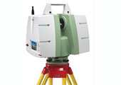
Research tools available in the lab include a Leica-Geosystems ScanStation C10 3D
laser scanner. The Leica ScanStation C10 includes a high-accuracy/long-range scanner,
tilt sensor, battery, controller, data storage, auto-adjusting video camera and laser
plummet all in one compact, portable instrument. The ScanStation C10 also features major
productivity advances, including a Smart X-Mirror™ design that lets users conduct full-dome
scans in literally a few minutes using a spinning mirror or conduct small area scans
efficiently with Smart X-Mirror's oscillating mode.
Marine Radar -- Furuno 1525 MK3 - 25 kW radar unit
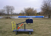
Marine Radar -- Furuno 1525 MK3 - 25 kW radar unit (range scales 1/8-96 n.mi.) with a 6.5 ft.
horizontal array antenna and a digitizing card XIR3000 by Russell Technologies Inc.
LAI-2200C Plant Canopy Analyzer
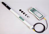
The LAI-2200C Plant Canopy Analyzer is a non-destructive way to easily and accurately measure Leaf
Area Index (LAI). The passive sensor is used to compute LAI among variety of other canopy structure
attributes from radiation measurements. The instrument integrates a fish-eye optical sensor with
five silicon detectors arranged in circular rings that samples radiation above canopy and below
canopy at five zenith angles simultaneously.
Trimble Yuma™ rugged tablet computer
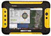
Trimble Yuma™ rugged tablet computer designed for ease of use and high performance mobility.
Our Trimble Yuma with ArcPad is an integrated and rugged GIS/GPS tablet computer that is built
to withstand even the most challenging work environment.
Laser Technology TruPulse 360R Laser Rangefinder
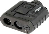
Laser Technology TruPulse 360R Laser Rangefinder w/ Integrated Bluetooth.
With a rugged, waterproof enclosure, the TruPulse 360R rangefinder can
measure distances, height and azimuth in harsh conditions.