TEAM

FACULTY
E-mail: peterg@bgsu.edu
Web: http://personal.bgsu.edu/~peterg
Office: Room 181, Overman Hall
Phone: (419) 372-7201
[Google Scholar] [ResearchGate]
Web: http://personal.bgsu.edu/~peterg
Office: Room 181, Overman Hall
Phone: (419) 372-7201
[Google Scholar] [ResearchGate]
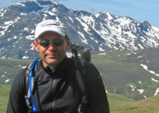
Peter Gorsevski, Ph.D.
Associate Professor, Geospatial Sciences
School of Earth, Environment and Society
Associate Professor, Geospatial Sciences
School of Earth, Environment and Society
Dr. Gorsevski received a Ph.D. degree in Natural Resources from the University of
Idaho (2002), an M.S. in Forest Engineering from Oregon State University (1996) and
a B.S. in Forestry from Ss. Cyril and Methodius University, Republic of Macedonia
(1992). Dr. Gorsevski is currently an Associate Professor in Geospatial Sciences at the
Bowling Green State University in the School of Earth, Environment & Society. His
research interests include Geoinformatics, Geocomputation, Wind Energy and Avian
Interaction Spatial Decision Support Systems and Remote Sensing and Airborne Sensor
Development.
Education & Experience
Ph.D., University of Idaho, Moscow, Idaho (1998-2002)
M.S., Oregon State University, Corvallis, Oregon (1994-1996)
B.S., Forestry, University Ss. Cyril and Methodius, Skopje, Republic of Macedonia (1986-1992)
Associate Professor, School of Earth, Environment & Society, Bowling Green State University (2013-Present)
Assistant Professor, School of Earth, Environment & Society, Bowling Green State University (2007-2013)
Assistant Director, Sustainability and the Environment Center of Excellence, Bowling Green State University, Bowling Green, OH (2010 – Present)
Adjunct Assistant Professor, Forest Resources, University of Idaho, Moscow, ID (2004-2007)
Remote Sensing Research Scientist, University of Idaho (2004 – 2007)
Instructor, Forest Resources, University of Idaho (Spring Semester 2003)
Postdoctoral Fellow, Forest Resources, University of Idaho (2002 - 2004)
Co-Instructor, Forest Resources, University of Idaho (Fall Semester 2001)
Instructor, Forest Resources, University of Idaho (Fall Semester 1999)
Graduate Teaching Assistant, Forest Resources, University of Idaho (1998 - 2000)
Guest lecturer, Department of Geography and Forest Products, University of Idaho
Graduate Teaching Assistant, Forest Engineering, Oregon State University (1995 - 1996)
Graduate Research Assistant, Forest Engineering, Oregon State University (1994 - 1995)
Specialty Areas of Interest
GIScience Analysis Methods, Spatial Statistics, and Data Mining
GIS Multicriteria Decision Analysis & Spatial Decision Support Systems
Remote Sensing & Photogrammetry
Airborne Sensor Development
Landslide Hazard Modeling
Terrain and Watershed Analysis
GIS Multicriteria Decision Analysis & Spatial Decision Support Systems
Remote Sensing & Photogrammetry
Airborne Sensor Development
Landslide Hazard Modeling
Terrain and Watershed Analysis
Current BGSU Courses
Weather and Climate - Ugrad
Spatial Modelling - Grad
Geospatial Science -Ugrad
Spatial Statistics - Grad
Quantitative Methods -Ugrad
Remote Sensing of the Environment - Grad
Spatial Modelling - Grad
Geospatial Science -Ugrad
Spatial Statistics - Grad
Quantitative Methods -Ugrad
Remote Sensing of the Environment - Grad
Recent and Current Research or Grants
Coastal Ohio Wind Project for Reduced Barriers to Deployment of Offshore Wind Energy (PI), US DOE Energy Efficiency & Renewable Energy (DE-EE0003871), $1,000,000, FY 11-13
Coastal Ohio Wind (PI), US DOE Energy Efficiency & Renewable Energy (DE-FG36-06GO86096), $1,600,000, FY 11-12
Coastal Ohio Wind (PI), US DOE Energy Efficiency & Renewable Energy (DE-FG36-06GO86096), $1,600,000, FY 11-12
Recent Peer Reviewed Publications and Submissions
Alcorn R, Panter KS, . (In press).
A GIS-based volcanic hazard and risk assessment of eruptions sourced within Valles Caldera, New Mexico.
Journal of Volcanology and Geothermal Research, http://dx.doi.org/10.1016/j.jvolgeores.2013.09.005
Jarrah A, Jamali MM, Ross J, , Frizado J, Bingman VP. 2013. Sensitivity analysis
for optimal parameters for marine radar data processing. American Journal of Signal Processing,
3(3): 78-83, DOI:10.5923/j.ajsp.20130303.05
, Cathcart SC, Mirzaei G, Jamali MM, Ye X, Gomezdelcampo E. 2013.
A group-based spatial decision support system for wind farm site selection in
northwest Ohio. Energy Policy 55:374–385
OTHER COLLABORATORS
CURRENT AND PAST STUDENTS
Finhas Tsehaye Zerai
Graduate Student, Geospatial Science
Department of Geology
Graduate Student, Geospatial Science
Department of Geology
Finhas is a second-year geology graduate student at SEES - BGSU and holds BSc degree in Geology from University of Asmara – Eritrea. After graduation he was involved in applied geoscience studies ranging from groundwater exploration and assessment, near-surface geophysics, mineral exploration to environmental studies in his country. Working in government authorities, he led and successfully accomplished several groundwater exploration and development projects by employing hydrogeological / geological field investigation methods, electrical resistivity geophysical surveys and GIS tools. Finhas’s geoscience experience further expanded into precious and base metal exploration (gold, copper, zinc & iron) as well as potash mineral exploration in underexplored region of Arabian-Nubian shield geologic setting that straddles East Africa and Arabia regions.
His ongoing thesis integrates remote sensing and GIS / machine learning techniques in identifying prospective zones of mineralization in southwestern part of Eritrea (Kerkasha project); in accomplishing these tasks he uses ASTER and surface geochemical data, among others, and is employing R programming language and publicly available geospatial analysis softwares ( e.g. QGIS / SAGA) in processing and analyzing the geospatial data. By taking the necessary graduate courses, Finhas is also further aiming to be conversant with newly developing artificial intelligence tools for geospatial data analysis and be skillful in R and Python programming languages for such analysis.
His ongoing thesis integrates remote sensing and GIS / machine learning techniques in identifying prospective zones of mineralization in southwestern part of Eritrea (Kerkasha project); in accomplishing these tasks he uses ASTER and surface geochemical data, among others, and is employing R programming language and publicly available geospatial analysis softwares ( e.g. QGIS / SAGA) in processing and analyzing the geospatial data. By taking the necessary graduate courses, Finhas is also further aiming to be conversant with newly developing artificial intelligence tools for geospatial data analysis and be skillful in R and Python programming languages for such analysis.
Education & Experience
MS, Geology, Bowling Green State University (2020-2022)
BSc – Geology (2003), University of Asmara
BSc – Geology (2003), University of Asmara
Achievements and Awards
Graduate teaching assistantship - BGSU (2020-2022)
Graduate teaching assistantships - Northern Illinois University (2019) and BGSU (2009)
Full DAAD scholarship for MSc in hydro science and engineering at TU-Dresden Germany (2006 & 2007)
Dean’s list of students with highly commendable performances, University of Asmara (2001 – 2002)
Graduate teaching assistantships - Northern Illinois University (2019) and BGSU (2009)
Full DAAD scholarship for MSc in hydro science and engineering at TU-Dresden Germany (2006 & 2007)
Dean’s list of students with highly commendable performances, University of Asmara (2001 – 2002)
Experience
Teaching assistant at SEES – BGSU, USA (2022 - Present)
Senior Geologist, Interu mining and trading DMCC, Eritrea (2017 - 2019)
Hydrogeologist and geologist, South Boulder Mines ltd, Eritrea (2014 -2015)
Project geologist, Sahar Minerals ltd, Eritrea (2011-2013)
Hydrogeologist, Water Resources Department of Eritrea, Eritrea (2003 - 2010)
Senior Geologist, Interu mining and trading DMCC, Eritrea (2017 - 2019)
Hydrogeologist and geologist, South Boulder Mines ltd, Eritrea (2014 -2015)
Project geologist, Sahar Minerals ltd, Eritrea (2011-2013)
Hydrogeologist, Water Resources Department of Eritrea, Eritrea (2003 - 2010)
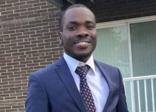
Michael Kofi Mborah Amoah
Graduate Student, Geospatial Science
Department of Geology
Graduate Student, Geospatial Science
Department of Geology
Michael holds a Bachelor of Science in Geomatic Engineering from Kwame Nkrumah University of Science and Technology in Ghana. During his time with Jan De Nul Ltd., he worked on a port expansion project at Takoradi. In addition, he worked with the Ghana National Petroleum Corporation (GNPC) on an onshore 2D seismic project. He was a Teaching Assistant for the Department of Geology, at BGSU. His master's final project was titled "Mapping Wetlands Using GIS and Remote Sensing Techniques, a Case Study of Wetlands in Greater Accra, Ghana". The study investigated a variety of land use changes over time in an urban region, as well as their impacts on ecosystems, and projected future impacts based on previous trends, to provide better context for land planning and management by policymakers. Among his interests are Remote Sensing, GIS, Land Surveying, and Hydro surveying.
Education & Experience
MS, Geology, Bowling Green State University (2020-2022)
BS, Geomatic Engineering, Kwame Nkrumah University of Science & Technology (2013-2017)
Teaching Assistant, Department of Geology, Bowling Green State University (2020-2022)
Surveyor Assistant, Geology Department Ghana National Petroleum Corporation (2017-2018)
BS, Geomatic Engineering, Kwame Nkrumah University of Science & Technology (2013-2017)
Teaching Assistant, Department of Geology, Bowling Green State University (2020-2022)
Surveyor Assistant, Geology Department Ghana National Petroleum Corporation (2017-2018)
Achievements and Awards
Full scholarship from Bowling Green State University, 2020-2022
Best Geology Personnel from GNPC, 2017-2018
Best Geology Personnel from GNPC, 2017-2018
Paul W. O'Malley
Graduate Student, Geospatial Science
Department of Geology
Graduate Student, Geospatial Science
Department of Geology
Paul previously earned B.S. degrees in Electrical Engineering from Northwestern University and in Geology from Indiana University. He also holds a Juris Doctor degree from Valparaiso University. He is admitted to the practice of law in Illinois, Indiana and Minnesota. Paul worked for two years in civil litigation in Chicago, Illinois before working several years as a patent attorney. Paul?s patent work included exposure to a variety of technologies including, computer operating systems, diesel engines, disk drives, main frame computer design, semi-conductors, and acoustic systems. As a non-traditional student his interests are geomorphology, particularly aeolian processes. His research at Bowling Green State University focused on the application of geospatial analysis to stabilized sand dunes. Paul previously interned (Summer 2015) with the Arizona State University Planetary Aeolian Laboratory located at NASA's Ames Research Center.
Education & Experience
BSc. Geology, Indiana University-Purdue University at Fort Wayne (2013-2016)
Doctor of Law (J.D.) Valparaiso University (1980-1982)
Economics, Carnegie Mellon University Tepper School of Business (1978-1979)
Indiana University School of Law - Bloomington(1977-1978)
BSc. Electrical Engineering , Northwestern University (1973-1977)
Doctor of Law (J.D.) Valparaiso University (1980-1982)
Economics, Carnegie Mellon University Tepper School of Business (1978-1979)
Indiana University School of Law - Bloomington(1977-1978)
BSc. Electrical Engineering , Northwestern University (1973-1977)
Asanga Ramanayake
Graduate Student, Geospatial Science
Department of Geology
Graduate Student, Geospatial Science
Department of Geology
Asanga Ramanayake is a first year master’s student from Sri Lanka. He earned his Bachelor’s degree from
University of Peradeniya. His major was Computer Science. He worked as a Software Engineer in C for 3 years
in Sri Lanka. He has involved in developing banking software solutions in Sri Lanka, Malaysia and Singapore.
He is currently studying as a Graduate Student in Geo-spatial science, Bowling Green State University.
His research interests are big data processing using Hadoop and real time spatial data analysis.
Education & Experience
BSc. University of Peradeniya, Sri Lanka (2008-2011)
MSc. University of Peradeniya, Sri Lanka (2013-2015)
Software Engineer, Epic Lanka Technologies(pvt) Ltd, Sri Lanka (2011-2014)
MSc. University of Peradeniya, Sri Lanka (2013-2015)
Software Engineer, Epic Lanka Technologies(pvt) Ltd, Sri Lanka (2011-2014)
Udaya Jayawardhana
Graduate Student, Geospatial Science
Department of Geology
Graduate Student, Geospatial Science
Department of Geology
Udaya Jayawardhana is a second year Master’s student in Geospatial Sceinece from Sri Lanka.
He earned his Bachelor’s degree in Computer Science from University of Colombo School of Computing.
After his graduation he worked as a Software Engineer in few IT firms from 2009 to 2013.
During his career, he involved in designing and development of web based systems using various
cloud and web technologies specially for Banking, Human Resource Management,
Shipping and Apparel Manufacturing industries. While he was working, he earned his Master's
degree in Computer Science from the same university in 2013. His Master’s thesis titled
"An email interpretation system for dry cargo chartering" which explored methods for real time
information extraction from unstructured dry cargo chartering emails using Natural Language techniques.
Currently he is involving in research related to web based geospatial systems and information extraction from crowd sourced unstructured data in the GeoInformatics Laboratory, Bowling Green State University, Ohio. He is interested in pseudo real time analysis and presentation of temporal and spatial distribution of trends using crowd sourced unstructured data.
Currently he is involving in research related to web based geospatial systems and information extraction from crowd sourced unstructured data in the GeoInformatics Laboratory, Bowling Green State University, Ohio. He is interested in pseudo real time analysis and presentation of temporal and spatial distribution of trends using crowd sourced unstructured data.
Education & Experience
Bachelor of Computer Science, University of Colombo School of Computing, Sri Lanka (2006-2009)
Master of Computer Science, University of Colombo School of Computing, Sri Lanka (2011-2013)
Software Engineer, ESD - Prime Engineering (pvt) Ltd., Sri Lanka (2009-2010)
Software Engineer, Ascensor Partners (pvt) Ltd., Sri Lanka (2010-2011)
Software Engineer, Sabre Technologies (Pvt) Ltd., Sri Lanka (2011-2012)
Software Engineer, Attune Consulting (pvt) ltd., Sri Lanka (2013)
Nayani Ilangakoon
Graduate Student, Geology
Department of Geology
Graduate Student, Geology
Department of Geology
Nayani Ilangakoon was a master’s student from Sri Lanka. She earned her Bachelor’s
degree in Geology from University of Peradeniya. She worked as a Teaching Assistant at the
Department of Geology, University of Peradeniya and as a Geologist at Geological Survey and
Mines Bureau, Sri Lanka. She has involved several mineral exploration and mapping projects at
her career in Sri Lanka. Currently, she works as a Research Assistant at the Department of Geology,
BGSU. Her Master’s thesis titled “Relationship between Leaf Area Index (LAI) Estimated by Terrestrial
LiDAR and Remotely Sensed Vegetation Indices as a Proxy to Forest Carbon Sequestration” explores the
application of Terrestrial LiDAR for Leaf area index measurements. This further investigates the
associated uncertainty when use vegetation indices to measure the spatial distribution of LAI.
She is interested in application of LiDAR remote sensing in forestry and crop parameter analysis
and modeling.
Education & Experience
BSc., Geology, University of Peradeniya, Sri Lanka (2005-2009)
Geologist, Geological Survey and Mines Bureau, Sri Lanka (2010-2012)
Research Assistant, Department of Geology, Bowling Green State University (2012-Present)
Geologist, Geological Survey and Mines Bureau, Sri Lanka (2010-2012)
Research Assistant, Department of Geology, Bowling Green State University (2012-Present)
Awards and Scholarships
Richard D Hoare Graduate Research Scholarship (BGSU,USA, 2012)
Academic Excellence Award (University of Peradeniya, Sri Lanka, 2009)
P.W.Vithanage Scholarship (University of Peradeniya, Sri Lanka, 2007-2008)
Academic Excellence Award (University of Peradeniya, Sri Lanka, 2009)
P.W.Vithanage Scholarship (University of Peradeniya, Sri Lanka, 2007-2008)

Xiaohui Liu
Graduate Student, Geology
Department of Geology
Graduate Student, Geology
Department of Geology
Xiaohui Liu was a graduate student from China. She earned her Bachelor’s
degree in Geography Information System (GIS) from Shandong Jianzhu University and her
Master’s Degree in Geography Information Engineering from Liaoning Technical University,
China. She once worked as a visiting graduate student at Chinese Academy of Science on
GIS software development. Currently, she works as a Research Assistant at the Department
of Geology, BGSU. Her Master’s thesis titled “Web-based Multi-Criteria Evaluation of Spatial
Trade-Offs between Environmental and Economic Implications from Hydraulic Fracturing in a
Shale Gas Region in Ohio” focuses on a Web-based Spatial Decision Support System (SDSS)
tool for assisting policy-makers in choosing suitable areas for hydraulic fracturing
based on participants’ votings. The proposed tool will enable the public to express
their concerns as well as to participate in the communications and consensus
building process through manipulating the trade-offs between environmental
and economic implications from hydraulic fracturing activities in Ohio.
Education & Experience
BSc., Geography Information System (GIS), Shandong Jianzhu University, China
MSc., Geography Information Engineering, Liaoning Technical University, China
Research Assistant, Department of Geology, Bowling Green State University(2012 - present)
MSc., Geography Information Engineering, Liaoning Technical University, China
Research Assistant, Department of Geology, Bowling Green State University(2012 - present)
Achievements and Awards
Mancuso Family Field Studies Scholarship (BGSU, USA) 2012
Outstanding Community Cadres (Liaoning Technical University, China) 2010
National Encouragement Scholarship (Shandong Jianzhu University, China) 2009
Outstanding Community Cadres (Shandong Jianzhu University, China) 2006
Outstanding Community Cadres (Liaoning Technical University, China) 2010
National Encouragement Scholarship (Shandong Jianzhu University, China) 2009
Outstanding Community Cadres (Shandong Jianzhu University, China) 2006

Alberto Manzano Torregrosa
Research Assistant, Computer Science
Department of Computer Sciences
Research Assistant, Computer Science
Department of Computer Sciences
Alberto Manzano Torregrosa was a Computer Science graduate student from Spain.
He earned his Bachelor's degree in Computer Science from University of Alcalá (Madrid, Spain).
He has more than 4 years of experience working as a Java Developer and Analyst for
different companies in Madrid (Spain). He was a graduate assistant during the
2013 academic year, and his research focused on developing Android applications
with GIS capabilities for mobile and tablet devices. His Master's Final Project
is titled "Multi-Criteria Evaluation Android Application for a Wind Farm Site
Selection". His interests include: Software Engineering, Mobile Applications
Development, and Mobile Applications Design.
Education & Experience
BSc., Computer Science, University of Alcalá (UAH), Madrid, Spain
MSc., Computer Science, Bowling Green State University (2013 - present)
Research Assistant, Department of Geology, Bowling Green State University (2013)
MSc., Computer Science, Bowling Green State University (2013 - present)
Research Assistant, Department of Geology, Bowling Green State University (2013)
Achievements and Awards
Full scholarship from Universidad de Alcalá, 2001-2005
Scholarship for studying English abroad from Universidad de Alcalá, 2007
Full scholarship from Bowling Green State University, 2013-2014
Scholarship for studying English abroad from Universidad de Alcalá, 2007
Full scholarship from Bowling Green State University, 2013-2014
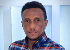
Addisu Dereje Mekonnen
Former Graduate Student, Geology (2012-2014)
Department of Geology
Former Graduate Student, Geology (2012-2014)
Department of Geology
Addisu D. Mekonnen was a graduate student from Ethiopia. He earned his Bachelor’s Degree in Geology
and Geophysics and his Masters Degree in GIS and Remote Sensing from Addis Ababa University (AAU),
Ethiopia. He had worked for a range of organizations including the U.S. Agency for International Development
(USAID), the European Commission (EC), Nile Basin Initiative (NBI) under the United Nations Office for Project
Services (UNOPS) both as a full time and a consultant. He was a research assistant while he was a graduate
student at Bowling Green State University. His master’s thesis was titled “A web-based participatory
GIS (PGIS) for offshore wind farm suitability within Lake Erie, Ohio”. The developed PGIS prototype
integrates GIS and decision-making tools that are intended to involve different stakeholders and the
public for solving complex planning problems in suitable offshore wind site selection and building
consensus among them.
Education & Experience
BSc., Geology and Geophysics, Addis Ababa University (AAU), Ethiopia
MSc., GIS and Remote Sensing, Addis Ababa University (AAU), Ethiopia
MSc., Department of Geology, Bowling Green State University (2012 - 2014)
MSc., GIS and Remote Sensing, Addis Ababa University (AAU), Ethiopia
MSc., Department of Geology, Bowling Green State University (2012 - 2014)
Achievements and Awards
Full scholarship from Bowling Green State University, 2012-2013

Arisca Droog
Graduate Student, Geospatial Science
Department of Geology
Graduate Student, Geospatial Science
Department of Geology
Arisca was a graduate student from the Netherlands.
Education & Experience
MS, Geology, Bowling Green State University (2010-2012)
BA, Geography, Bowling Green State University (2006-2010)
BA, Geography, Bowling Green State University (2006-2010)

M. Kenneth Brown
Graduate Student, Geospatial Science
Department of Geology
Graduate Student, Geospatial Science
Department of Geology
Kenny's experience include: Digital Mapping,GIS Modeling and Analysis, Spatial Analysis Using R, Interpretation of Remote Sensing Data, Analysis of Slope Stability and Mitigation, Determining Faults and Structure in the Field, Petrographical Analysis, Computer Skills Including: ArcGIS, ILWIS, IDRISI, R, IgPet, Surfer, Rockpack, E. R. Mapper, Minitab, Microsoft office.
Education & Experience
MS, Geology, Bowling Green State University (2010-2012)
BA, Geography, Bowling Green State University (2004-2009)
BA, Geography, Bowling Green State University (2004-2009)

Steven C Cathcart
Graduate Student, Geospatial Science
Department of Geology
Graduate Student, Geospatial Science
Department of Geology
Steven worked on a spatial decision support system to promote collaboration among multiple decision makers in order to obtain optimal locations for a new wind farm in Ohio and published results in a Master's Thesis. Developed Python scripts to manipulate multiple datasets and constructed spatial models using the ModelBuilder application. Created an interactive GUI that allowed clients to develop unique spatial decision alternatives based on quantitative information they submitted. Presented results of the research to multiple audiences, including: regional planning committees, business developers, and energy professionals
Education & Experience
MS, Geology, Bowling Green State University (2009-2011)
BA, Environmental Policy and Analysis, Bowling Green State University (2005-2009)
BA, Environmental Policy and Analysis, Bowling Green State University (2005-2009)