RESEARCH PROJECTS
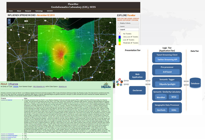
This web-based prototype software framework (Fluwitter) performs pseudo real-time detection of influenza outbreaks from Twitter in space and time. The server side system is composed of a PostGIS spatial database, a GeoServer instance, a web application for visualizing influenza maps and daemon applications for tweet streaming, pre-processing of data, semantic information extraction based on DBpediaSpotlight and WS4J, and geo-processing. The collected geo-tagged tweets are processed by semantic NLP techniques for detecting and extracting influenza related tweets. Identified influenza tweets are presented on a web GIS interface as daily influenza maps.

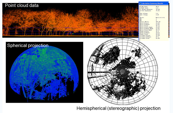
Relationship between Leaf Area Index (LAI) estimated by terrestrial LiDAR and remotely sensed
vegetation indices as a proxy to forest carbon sequestration
The research uses a terrestrial laser scanning (TLS), also known as ground-based LiDAR (Light Detection and Ranging) which has been used as an alternative indirect method for quantifying aboveground biomass and LAI. The aim of this project is to generate estimates of tree leaf area based on small-footprint LiDAR-derived measurements and to quantify the uncertainty associated with the parameter estimates in the prediction of LAI using Bayesian Inference. The integration of Bayesian inference with Markov Chain Monte Carlo (MCMC) simulation with Gibbs sampling is used to estimate the uncertainty.

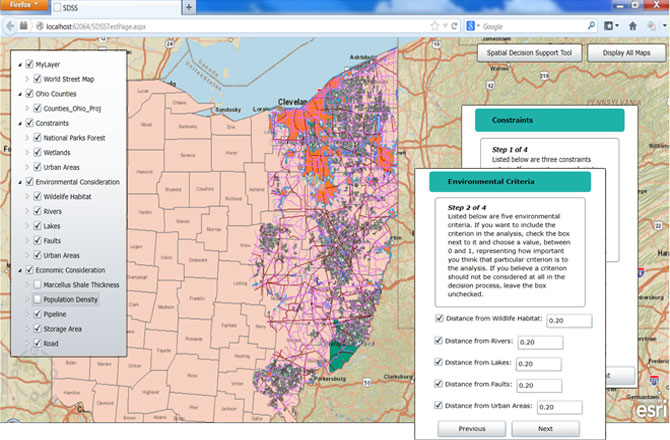
The main objective of this tool is to demonstrate a web-based SDSS tool for assisting policy-makers in
choosing suitable areas for hydraulic fracturing based on participants' input. The proposed web-based
SDSS tool will enable the public to express their concerns as well as to participate in the
communications and consensus building process through manipulating the trade-offs between
environmental and economic implications from hydraulic fracturing activities in Ohio. The
potential users of this tool are the residents who live in the study area, policy makers,
stakeholders, and other participants that show interest in the problem.
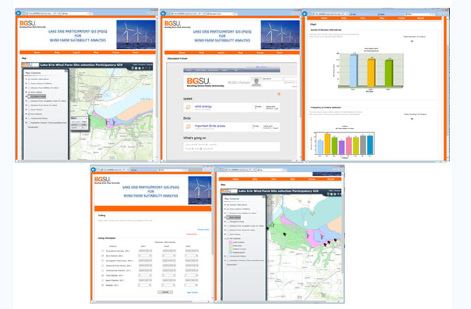
A web-based Participatory Geographic Information System (PGIS) framework intended for offshore wind suitability analysis
The PGIS prototype integrates GIS and decision-making tools that are intended to involve different stakeholders
and the public for solving complex planning problems and building consensus. Public involvement from the early
planning stage of projects with a spatial nature is very important for future legitimacy and acceptance of these
projects. Therefore, developing and executing a system that facilitates effective public involvement for
resolving contentious issues can help in fostering long-lasting agreements. The prototype is a distributed
and asynchronous PGIS that combines a discussion forum, a mapping tool and a decision tool.
This research focused on developing Android applications for SDSS for mobile and tablet devices.
In particular we are developing a mobile application that integrated GIS capabilities and
Multi-Criteria Evaluation analysis .
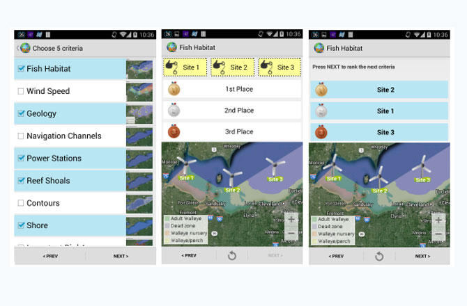
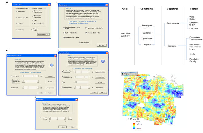
The multiple criteria evaluation (MCE) prototype system is intended for
regional planning but also for promoting group decision making that could
involve participants with different interests in the development of
decision alternatives. The framework integrates environmental and
economic criteria and builds a hierarchy for wind farm siting
using weighted linear combination (WLC) techniques and GIS
functionality. The SDSS allows the multiple participants to
interact and develop an understanding of the spatial data
for assigning importance values to each factor.
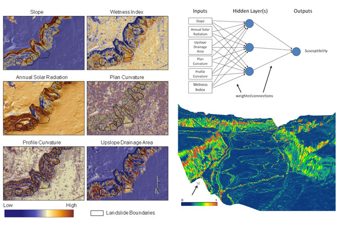
Landslide detection and susceptibility mapping using LiDAR and ANN modeling: Cuyahoga River Valley, Ohio
This study detects shallow landslides using hillshade maps derived from
Light Detection and Ranging (LiDAR)-based Digital Elevation Model (DEM).
The landslide susceptibility mapping used an Artificial Neural Network
(ANN) approach and back propagation method that was tested in the
northern portion of the Cuyahoga Valley National Park (CVNP)
located in Northeast Ohio. The relationship between landslides
and different predictor attributes extracted from the LiDAR-based-DEM
such as slope, profile and plan curvatures, upslope drainage area,
annual solar radiation, and wetness index was evaluated using a
Geographic Information System (GIS) based investigation.